77 Saint Pierre & Miquelon (France)

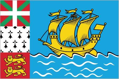
A yellow three-masted sailing ship facing the hoist side rides on a blue background with scattered, white, wavy lines under the ship. A continuous black-over-white wavy line divides the ship from the white wavy lines. On the hoist side, a vertical band is divided into three parts: the top part (called ikkurina) is red with a green diagonal cross extending to the corners overlaid by a white cross dividing the rectangle into four sections; the middle part has a white background with an ermine pattern; the third part has a red background with two stylized yellow lions outlined in black, one above the other. These three heraldic arms represent settlement by colonists from the Basque Country (top), Brittany, and Normandy. The blue on the main portion of the flag symbolizes the Atlantic Ocean and the stylized ship represents the Grande Hermine in which Jacques Cartier “discovered” the islands in 1536.

Flag courtesy of the CIA World Factbook

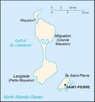
Map courtesy of the CIA World Factbook

Google Earth

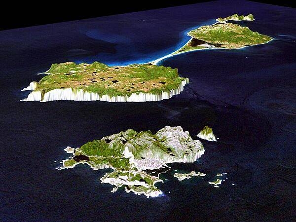
A 3-D perspective view of Miquelon (background) and Saint Pierre Islands (forefront), located south of Newfoundland, Canada. These islands, along with five smaller islands, are a self-governing territory of France. North is in the top right corner of the image.

Photo courtesy of the CIA World Factbook

Last updated on April 18, 2024

Government

According to Britannica, the islands are presided over by a French-appointed prefect, who is assisted by a privy council and an elected general council. The inhabitants possess French citizenship and suffrage. Primary education is free and mostly parochial. Saint-Pierre, the territorial capital, is the seat of the law courts and the apostolic prefecture.

The first explorer to visit the archipelago was a Portuguese, José Alvarez Faguendez, who landed there in 1520. The first permanent French fishing settlement was established in 1604. The islands were subsequently exchanged between the French and British several times until restored permanently to France in 1816 under the Treaty of Paris (1814). The islands became a French overseas territory in 1946 and then, in 1976, an overseas département, on a presumed par with the départements of metropolitan France. In May 1985 the islands were given a new status with a new name, collectivité, because the former departmental arrangement conflicted with the tariff structure of the European Community (now European Union), to which France belongs.

Civil / National Aviation Authority (CAA/NAA)

The DGAC, the French Civil Aviation Authority, is responsible for ensuring the safety and the security of French air transport, as well as maintaining a balance between the development of the air transport sector and environmental protection. It is the national regulatory authority, but it also provides safety oversight, air navigation services and training. He is a partner of key players in the aeronautical industry and he is also in charge of financial aid for research in aircraft construction and state industrial policy in this sector.

Airspace

SkyVectorGoogle MapsADS-B Exchange

ICAO countries publish an Aeronautical Information Publication (AIP). This document is divided into three parts: General (GEN), En Route (ENR) and Aerodromes (AD). ENR 1.4 details the types of airspace classes they chose to adopt from classes A through G. Saint Pierre. and Miquelon eAIP

Airspace Classification

Airspace Classification

Drone Regulations

French Drone Laws

European regulations cover the design, maintenance and, to a large extent, the operation of drones, including training requirements and operator obligations. It is common to all EU Member States and is also applied by certain third countries (such as Norway, Iceland, Lichtenstein and Switzerland). It therefore has the advantage of harmonizing the requirements in all EU Member States.
European regulations base their requirements solely on the risk levels of operations:

  • the Open category for low-risk operations,
  • the specific category for moderate-risk operations, and finally
  • the certified category for high-risk operations.

The commercial or professional nature of an operation is not taken into account in the risk assessment.
National regulatory texts remain applicable, in particular to regulate matters falling under national authorities, such as security or the use of French airspace.

These pages provide an overview of the main steps to follow for a drone operator. This content is complemented by guides published by the Direction de la Sécurité de l’Aviation Civile

Guides

Whether you are an operator in an open or specific category, remote pilot or owner of a remotely piloted aircraft, AlphaTango® will allow you to carry out most of the administrative procedures necessary for your activity online.

Model Aircraft Associations

Aeromodelling is a historical activity which was governed by national regulations. European Regulation (EU) 2019/947 has entered into force but allows Member States to define and enforce national rules for model aircraft associations. This is the choice made by France, by defining at national level the safety requirements applicable to model aircraft and their remote pilots when these activities are carried out within a model aircraft association.

All the elements appearing on this page come from the Guide intended for model aircraft associations . Its reading is highly recommended! For any additional information, a Frequently Asked Questions is available below. This FAQ is taken from the now closed Slido Q&A site.

Q&A on European regulatory transition

European regulation 2019/947 concerns the use of unmanned aircraft on board and the requirements applicable to their operators. Although this regulation thoroughly reviews the operating conditions of aircraft without a crew on board, its article 16 allows Member States to define and apply national rules to model aircraft associations. This is the choice made by France, by defining at national level the safety requirements applicable to model aircraft and their remote pilots when these activities are carried out within a model aircraft association: these requirements are the subject of the “aeromodelling associations” decree which comes into force on December 31, 2020. The decree of December 17, 2015 relating to the design of civil aircraft which circulate without anyone on board,

This order applies to the operation within model aircraft associations:

  • of a model aircraft in view of its remote pilot;
  • of a model aircraft with a mass less than or equal to 2 kg, flying out of sight of its remote pilot (case of FPV practice), at a maximum horizontal distance of 200 meters from this remote pilot and at a maximum height of 50 meters, in the presence of a second person in view of this aircraft and responsible for ensuring the safety of the flight by informing the remote pilot of possible dangers;
  • a model aircraft with a mass of less than 1 kilogram which, once launched, evolves within the framework of autonomous operation by following the movements of the atmosphere and whose flight does not last more than 8 minutes (cf. case of aircraft uncontrolled §3.3).

Aeromodelling activities within aeromodelling associations must be the subject of an activity localization.

A model aircraft association can make a request to locate an activity by completing the CERFA 15478*02 form to be sent to the territorially competent DSAC/IR (see DSAC-IR contact details).

The activity location, published in the aeronautical information ( AIP ), includes the practical methods and in particular the maximum flight heights and whether night flying is authorized.

Any operation outside these locations of activity is described in the decree of December 3, 2020 relating to the use of airspace by aircraft without crew on board (article 5). This decree mentions in particular (but not exclusively):

  • the prohibition of flights above public space in built-up areas,
  • the obligation to notify flights in certain portions of airspace for model aircraft weighing more than 900 grams,
  • a maximum flight height of 120 meters.

Registration and registration of aircraft – Aircraft over 800g must be registered by their owner on the AlphaTango website. This portal allows a remote pilot to carry out all their procedures online. For more details, refer to the page dedicated to AlphaTango.

This obligation to register also applies to all aircraft concerned by electronic reporting (see below). Once the aircraft is registered, its owner is required to affix the registration number to the aircraft and must keep with him an extract from the register of remotely piloted aircraft. This extract must be able to be presented to the authorities in the event of an inspection.

Aircraft over 25 kg must be registered and checked in. The applicable procedure is available below:

Electronic and light signaling – This obligation applies to unmanned aircraft with a mass greater than or equal to 800 g.

Model aircraft categories – The regulations distinguish two categories of model aircraft:

Category A: Model aircraft with a mass of less than 25 kg, non-motorized or comprising a single type of propulsion and respecting the following limitations:

  • Thermal engine(s): total displacement ≤ 250 cm3
  • Electric motor(s): total power ≤ 15 kW
  • Turboprop(s): total power ≤ 15 kW
  • Reactor(s): total thrust ≤ 30 daN, with a thrust/weight ratio without fuel ≤ 1.3
  • Hot air: total mass of gas in cylinders on board ≤ 5 kg

Any captive model aircraft with mass ≤ 150 kg

Category B: all model aircraft not respecting the characteristics of category A

Category B model aircraft can only be used after obtaining an authorization issued by the DGAC

General remote pilot requirements – In France, the minimum age to fly a drone over 800g as a remote pilot is 14 years old. The remote pilot must have undergone training and answered an online questionnaire with 100% correct answers (the number of attempts is unlimited).

This training can either be followed on the Open Category Training site or provided by the FFAM or UFOLEP, two federations whose training is recognized by the DGAC.

The certificate obtained is to be kept by the remote pilot who must be able to present it to the authorities in the event of an inspection.

If the remote pilot is not aged 14 or over or does not hold a training certificate, he must fly on a declared site, under the supervision of a person aged 16 or over and holder of the training certificate.

Special provisions are planned for international competitions, allowing foreign remote pilots to pilot in France for a limited period within the framework of these competitions.

For category B aircraft, the remote pilot must have proven his competence during a test flight and be mentioned on the aircraft’s flight authorization.

Training for pilots in model aircraft associations – The training set up by the DGAC, mandatory for aircraft weighing 800g or more, is recommended for everyone: it presents the essential rules and best practices in the form of videos and fun practical exercises. See the Training sheet for pilots in model aircraft associations.

Usage restrictions – Usage restrictions aim to ensure the safety of other airspace users as well as that of property and people on the ground.

Thus, there are restrictions on the places of flight and on the maximum authorized flight heights. These restrictions are published through aeronautical information, which makes it possible to consult permanent (AIP), urgent or temporary (NOTAM and SUP AIP) aeronautical information.

Outside model aircraft sites, the maximum overflight height is 120 m. Restrictions limiting the height to 120 m exist, for example in the vicinity of aerodromes.

The Geoportal map dedicated to restrictions for the flight of recreational drones will allow you to check your flight possibilities.

In general, the following are prohibited in model aircraft:

  • flights in public spaces in built-up areas,
  • night flights,
  • flying over gatherings of people,
  • the dropping of loads off model aircraft sites,
  • flights “out of sight” of the remote pilot, except in cases where the pilot flies “in immersion” with the assistance of an observer.

Since January 2021, the Civil Aviation Service of French Polynesia (SEAC-PF) has posted a map dedicated to restrictions for drone flights on the main islands of the Society archipelago.

Increase in maximum overflight heights outside model aircraft sites. – At places where the maximum permitted flight height is set at 120 m, the aircraft may rise to a maximum height of 150 m, depending on the conditions:

  • The aircraft is equipped with a telemetry system in working order allowing the remote pilot to know its height precisely;
  • The remote pilot is assisted by a visual observer in charge of detecting conflicts with other aircraft in the model aircraft’s range;
  • the remote pilot holds a training certificate issued by an aeromodelling association Law 1901 and registered as a UAS operator on AlphaTango , according to a program relating to the regulations applicable to unmanned aircraft on board used within the framework of aeromodelling associations , on the use of unmanned aircraft on board outside the locations of activity, on the risks associated with the proximity of other airspace users, on the verification and use of aircraft telemetry equipment , on the control of the height of the aircraft and the applicable limits, on the methods of coordination between remote pilot and observer, and on the procedures applicable in the event of detection of another aircraft.

Protection of the privacy of individuals – Individuals’ right to privacy must be respected. The people present must at least be informed if the aircraft is equipped with a camera or any other sensor likely to record data concerning them.

Any dissemination of an image making it possible to recognize or identify people (faces, license plates, etc.) must be authorized by the persons concerned or the owner in the case of a private space (house, garden, etc. ) and this dissemination must respect the rights to the image, privacy and private property of individuals.

Map of restricted areas for the Open category and model aircraft in metropolitan France – The map of restricted areas for the Open category and model aircraft in metropolitan France can be viewed on Geoportail.

The DGAC has developed with the help of the IGN (National Institute for Geographic and Forest Information) an interactive map of restrictions for recreational drones. It represents in a simplified and easily understandable way zones between 0 and 120m, on the whole of the French metropolitan territory, in which the flights of aircraft circulating without people on board are subject to prohibitions or restrictions. This map is based on the decree of December 3, 2020 relating to the use of airspace by aircraft circulating without anyone on board.

In areas where restrictions apply, flights are either totally prohibited or subject to specific authorization by the area manager. Flight in an open category without authorization is therefore not possible. In built-up areas, the flight of drones in the Open category is prohibited in public spaces.

The use of this card must be complementary and not substitute for a good knowledge of the regulations. Consultation of the “Open category” guide is essential.

Card support can be contacted at dgac-carte-drones@aviation-civile.gouv.fr.

While this map allows for an extended visualization of space restrictions, users’ attention is drawn to some current limitations:

  • private heliports are not included in the current version;
  • temporary bans on flying over natural areas during nesting periods are not represented. The existence of these zones is known in the prefecture;
  • In general, for all areas created on a temporary basis, it is advisable to consult the website of the Aeronautical Information Service.

Publication in FRANCE of geographical zones for aircraft without crew on board – Commission Implementing Regulation (EU) 2019/947 of 24 May 2019 concerning the rules and procedures applicable to the operation of unmanned aircraft on board provides in its article 15 that information relating to geographical areas for unmanned aircraft crew on board established for geovigilance purposes are made public by the States in a single and common digital format.

A geographical area is a part of the airspace in which special conditions apply to the operation of UAS for reasons of security, privacy and protection of personal data, safety or environmental.

In France, including in its overseas departments and communities, the special conditions that apply in the geographical areas are established by regulatory texts, including the decree of December 3, 2020 relating to the use of airspace by unmanned aircraft.

Geographical areas can take the form, for example, of controlled airspace, restricted or prohibited areas, hearts of national parks or areas signaling the presence of an establishment bearing a mark prohibiting overflight at low altitude. .

The first catalog of information relating to geographical areas is available in EUROCAE ED-269 format on the SIA website .

The file is accompanied by an explanatory notice which specifies in particular the conditions of use of this information and the procedures for updating it. It is up to the remote pilot to ensure that he complies with the regulations in force, in particular with regard to prohibitions on overflight below a certain height, which apply in national airspace.

Links and Resources – Guides published by the DSAC:

These guides, in the launch version, are continuously updated to incorporate the latest national regulatory references.

In addition, an introductory presentation intended for all categories of operators and manufacturers is also available.

For any additional information and questions, a question/answer site is available to you: we invite you to ask your questions or to vote for the questions asked by the other participants. The DSAC will answer the most frequently asked questions.

European regulations

  • Commission Delegated Regulation (EU) 2019/945 of 12 March 2019 on unmanned aircraft systems and third country operators of unmanned aircraft systems on board
  • Commission Implementing Regulation (EU) 2019/947 of 24 May 2019 concerning the rules and procedures applicable to the operation of unmanned aircraft on board


Punishments

The decree setting the criminal penalties applicable in the event of breaches of the obligations introduced by the law of November 24, 2016 was published on November 28, 2019.

For the use of unmanned aircraft on board with a mass greater than 800 grams, the lack of training of the remote pilot and of registration of the aircraft by its owner are now punishable by a fine.

Shooting

Training for remote pilots in model aircraft associations

Training intended for remote pilots in possession of an aircraft with a mass equal to or greater than 800g.

U-space: digital drone air traffic management

Since 2012 in France and more widely since 2019 in Europe, drone flights have had a regulatory framework aimed at offering the best conditions for the civil operation of these flying machines while preserving safety. These rules for access to airspace are supplemented by a solution common to all European Union countries and called “U-space”. U-space facilitates the use of drones that is safe and protective of the environment and privacy. With entry into force on January 26, 2023, the U-space regulatory framework benefits all operators, service providers, companies, communities and citizens concerned by the use of civilian drones.

U-space refers to air traffic management of unmanned aircraft (UAS), with a high level of automation and digitization, guaranteeing a safe integration of these drones into airspaces from a point of view. view of security and safety, but also respectful of the environment and protection of privacy.

The principle of U-space is the systematic use, in certain airspaces, of a set of digital services provided online to UAS operators or remote pilots. These services are designed for flight safety, including that of manned aviation.

All airspaces with a particular need – safety, security, environment or privacy – related to drones are likely to benefit from a “U-space”. This can concern any type of airspace, whether controlled or not, in urban or rural areas, around aerodromes or even in the airspaces of airports.

The 3 key elements of U-space

The U-space is based on 3 main elements:

  • Airspaces designated U-space by the State and in which the vast majority of aircraft flying there are drones. These spaces can be penetrated by manned aircraft under certain conditions:
  • Standardized digital services called “ U-space services ”. Four of these services are compulsorily provided to UAS operators inside U-space spaces. The providers of these services are called “U-space service providers” (USSP or U-space service provider). They must have a European certificate issued by the national authority of a European State or by the European Union Agency for Aviation Safety (EASA);
  • Common information services ( CIS or common information service), forming a basic digital infrastructure for each U-space. They consist of the provision of data allowing the use of U-space services and therefore circulation in U-space (e.g. information on airspace and traffic) for the needs of USSPs but also air navigation service providers, drone operators and all other stakeholders (eg Air Force).
    A single service provider in a U-space area may be designated by the State to provide these CIS services. This type of service provider is called a single CISP (common information service provider). He must also have a European certificate.

The U-space regulatory framework is based on three European Union regulations and a set of Acceptable Means of Compliance and EASA Guides:

Inside U-space, the following four services must be provided by USSPs to UAS operators:

  • Network ID service that enables continuous processing of UAS remote identification, operator registration, and dissemination of information about their operations, including drone and remote pilot positions
  • Geovigilance service , which informs UAS operators of applicable operating conditions in U-space and airspace constraints, including possible changes to the configuration of the space in which it is cleared to fly ( dynamic airspace reconfiguration )
  • UAS Flight Authorization Service , which grants UAS operators flight authorizations based on operating area interference with U-space constraints and other flight activities; the flight authorization service also provides for the review, or even the suspension, of each authorization according to changes in the conditions of evolution inside a U-space
  • Traffic Information Service , which aims to provide the UAS operator with information about any other discernible air traffic, including manned, that may be occurring near the UAS flight’s intended position or route and to allow him to take the necessary measures to avoid any risk of collision

The use of weather information service or compliance monitoring service may also be required by regulation, based on the airspace risk assessment . These optional services can also be offered at the initiative of the USSPs.

The performance of services provided by USSPs are specified based on an airspace risk assessment performed as part of the designation of each U-space.

Single USSPs and CISPs must have a certificate issued by the territorially competent national authority. It is the Civil Aviation Safety Department (DSAC) of the DGAC which is competent for the certification of these service providers whose main establishment is located in France. EASA is responsible for service providers who have their main establishment, are established or reside in a country outside the agency.

Certification is issued after instruction to service providers who can demonstrate their compliance with the applicable requirements of Commission Implementing Regulation (EU) 2021/664 of 22 April 2021 on a regulatory framework for U-space and its AMCs.

Certification by the DSAC takes place in 7 stages:

  1. Declaration of candidacy by the candidate service provider
  2. Appointment by the DSAC of an agent within it responsible for certification and implementation of a certification plan in coordination with the candidate service provider
  3. Production of a certification file by the candidate service provider
  4. Study of the certification file by the DSAC
  5. Certification audit by the DSAC of the candidate service provider, if applicable
  6. Treatment of any non-conformities
  7. Issuance of the certificate, if applicable

After certification, the service provider enters the continuous monitoring phase by the DSAC.

Exchanges between service providers and the DSAC, which are related to their certification or continuous monitoring, are carried out with the METEOR application

For any questions relating to the certification and monitoring of USSP and CISP service providers, contact: dsac-u-space-certification-ld@aviation-civile.gouv.fr

A file allowing candidates to apply for the issue of the European certificate of U-space service provider or single provider of common information services will soon be made available.

CISP (Common Information Service Provider): Common information service provider. They are said to be “single common information service provider” (single CISP) when they are designated by a State to provide the common information services on an exclusive basis in all or part of a U-space airspace

U-space airspace: a UAS geographical area designated by Member States, in which UAS operations are only permitted with the support of U-space services

Airspace risk assessment: an assessment of operational risks and safety and security risks, taking into account the required levels of safety performance defined in the European plan for aviation safety and the national program safety measures referred to, respectively, in Articles 6 and 7 of Regulation (EU) 2018/1139, the type, complexity and density of traffic, location, altitudes or heights and classification of the airspace

Electronic Perceivability: Ability to make itself permanently electronically perceivable to U-space service providers by one of the acceptable means of compliance with Regulation 2021/666 (e.g. ADS-B “Out” 1090 MHz)

Main establishment: the central administration or registered office of a U-space service provider or a common information service provider in the Member State in which the main financial functions and operational control of the provider are carried out Services

Dynamic Airspace Reconfiguration: the temporary modification of U-space airspace to accommodate short-term changes in manned aircraft traffic demand, by adjusting the geographical boundaries of that U-space airspace -space.

Common Information Service: a service disseminating static and dynamic data to enable the provision of U-space services for the purpose of traffic management of unmanned aircraft on board

U-space service: a service based on digital services and automation of functions, designed to ensure that a large number of UAS have secure, safe and efficient access to U-space airspace

UAS (Unmanned Aircraft System) or “aircraft system without a crew on board”: any aircraft without a crew on board and the equipment used to control it remotely

Flying a drone. –  Flying a drone in the archipelago, a few rules to know (translated below)

Drone Regulations Translated into English by Google

Translations

Translations of any materials into English are intended solely as a convenience to the public and are not legally binding. The author has merely attempted to provide a Google translation of the original material to English for convenience. Due to the nuances in translating to a foreign language, several differences may exist so before using for any work or pleasure please have the document translated by a professional service!

DRONES AND ARCHIPELAGO

More and more Saint-Pierrais and Miquelonnais will be brought with the return of beautiful days to use a drone. Although mostly looking like toys, these drones are considered to be aircraft and their users such as pilots (called telepilots). National regulations are applicable for the flight of these drones as well as their owners. Within our archipelago, given its small size, these regulations are very binding. In the first part are presented the rules of use of a drone within the archipelago. The second part presents detailed technical data for people wishing to go into the details of the regulations. In order to allow free use of drones, the prefecture of Saint-Pierre and Miquelon as well as the Civil Aviation Service of Saint-Pierre and Miquelon offer solutions.

First part : Fly a drone in the archipelago

1. General rules for flying a drone

General Rules for flying a drone

2. National regulations applying to drones and their pilots

2.1 Definitions
– A drone is an aircraft circulating without anyone on board.
– A populated area is defined within or at a horizontal distance less than 50 meters from an agglomeration shown on the maps aeronautical or at a horizontal distance of 150 meters from a gathering of people.
2.2 Reference texts
The use of a recreational drone is governed by 3 texts:
– The decree of 17 December 2015 relating to the design, use and the capabilities of drones;
– The decree of 17 December 2015 relating to the use of space air by drones;
– The law of October 24, 2016.

2.3 Rules for using drones
Flights performed with drones are classified as follows, and fall solely within these 2 categories:
– Aeromodelling activity: use for the purposes of leisure or competition. Aerial photography is possible in model aircraft during a flight whose objective remains the leisure or the competition and when the views taken are not operated on a commercial basis.
– Special activity: In order to be able to use a drone in the context of specific activities, the remote pilot is in particular subject to the possession of a theoretical aeronautical title official and the operator must be declared and approved by the DGAC. Is considered as a particular activity any use a drone that is not part of a leisure activity, that this use takes place within the framework of a transaction commercial or not.

On the other hand, drone flights take place:
– In View: the evolutions are located at a distance from the TV pilot such as this keeps a direct view of the aircraft and a clear view of the air environment making it possible to detect any approaching aircraft and prevent collisions. In this definition, direct sight is obtained without any optical device other than corrective glasses or eye contact lenses correctors.
– Out of view: developments that do not fall within the scope of the previous definition.
Finally, all drone flights must take place in the daytime and out of the clouds.

2.4 Aeromodelling activity
The name aeromodelling activity refers to a so-called leisure activity by individual.
The maximum height of use above the ground is set at 150 meters in the case general except within controlled airspace where specific heights apply or around aerodromes.
A drone used in this context must not perform maneuvers above public space in agglomeration except in places where the Prefect authorizes the activity of aeromodelling.

2.5 Special activity
In order to be able to use a drone in the context of activities particular, the telepilot is in particular subject to the detention an official theoretical aeronautical title and the operator must be declared and approved by the Directorate General of Aviation Civil.

The use of a drone in the context of specific activities cannot be done only according to 4 pre-established scenarios.
Drone flights falling within this regulatory framework fall under the use drone professional.
Some of these scenarios allow flight in populated areas under certain conditions.
In particular, drone operators will have to establish security perimeters on the ground in order to guarantee the protection of populations.
This category of activity is not currently present on the archipelago given the complexity of implementation and the regulatory requirements to be met.
People wishing to know more are invited to refer to the second part of this booklet.

2.6 Maximum heights of evolution within the archipelago in accordance with the national regulations
The following maps materialize the maximum drone flight heights in accordance with national regulations.

Maximum heights map

Maximum heights map

Maximum heights map

3. Adaptation of national regulations to our archipelago
In order to allow free use of drones, the prefecture of Saint-Pierre and Miquelon as well as the Civil Aviation Service of Saint-Pierre and Miquelon offer solutions.
On the other hand, the majority of drone flights taking place within the framework of activities of hobbies, only this activity will be mentioned below.
Thefts in the context of special activity are the subject of a detailed chapter in second part of this booklet.

3.1 The model aircraft field
The model aircraft field located in the diamond sector is located in the part where the maximum flight altitude is 0 (zero) meters.
However, the prefect having authorized the activity of aeromodelling on this land, he may be used by a remote pilot to fly a drone.
The telepilot must however be in good standing with the Saint Pierraise association. model aircraft and scrupulously respect the flight restrictions concerning this platform.
3.2 Flying in populated areas
No waiver of flight in populated area or above a gathering of people cannot be granted.
However, the Prefect of Saint-Pierre and Miquelon may consider a request duly substantiated on a case-by-case basis in order to issue an exceptional flight authorization.
3.2.1 Flying your drone within your private space in a built-up area
In agreement with the services of the Prefecture of Saint-Pierre and Miquelon, town halls of Saint-Pierre and Miquelon, the Territorial Council and Services of Civil Aviation, an individual can fly his drone in his space
private under the following conditions:
– The drone has a total mass not exceeding 800 grams (including including batteries and propellers);
– The drone is not equipped with any device allowing it to carry out shots (camera or still camera);
– The maximum flight height is limited to the ridge of the house located on private land;
– The owner of the drone guarantees to be insured in case of damage to property and persons resulting from its activity.
3.3 Definition of zones allowing to fly with less constraints
In order to allow the practice of the drone by the greatest number, it emerges in a way obvious the need to define some areas where the user can fly his drone with fewer constraints.
These areas must meet the requirements for the protection of populations and air traffic safety on the archipelago.
A joint action of the services of the Prefecture of Saint-Pierre and Miquelon and Civil Aviation allows these zones to be defined in 3 types given below:
– Green zone: Free use up to a height of 50 meters (a protocol will have to be established with the services of the Aviation Civil for a higher height).
– Orange zone: Use subject to prior authorization Civil Aviation Services.
– Red zone: Strictly prohibited use unless authorized of the Prefect.

These areas are shown on the following maps:
Fly your drone in a green area does not exempt you from complying with the general rules of use mentioned above (in particular points 1,4,6 and 7).

Saint Pierre

Saint Pierre map

The following areas are therefore subject to prefectural authorization:
– The agglomeration of Saint-Pierre;
– The western part of Ile aux Marins;
– The Saint-Pierre hydrocarbon depot;
– The EDF plant;
– The Galileo protected site.
Within the orange zone, the model aircraft field and the belvedere are represented by a green area.

Agglomeration of Saint-Pierre:

Agglomeration of Saint-Pierre map

Sailor Island:

Sailor Island map

Miquelon-Langlade:
Only the next band will be orange in color.
The rest of the territory of Miquelon and Langlade will be classified green.
The maximum height of movement in the green zone is 50 m so as not to interfere with the movement of aircraft that would be required to fly over this territory.

Miquelon-Langlade map

The agglomeration of Miquelon:

The agglomeration of Miquelon map

3.4 Derogatory protocols with the SAC-SPM
In order to be able to fly in orange-colored areas, a memorandum of understanding with the. SAC-SPM will have to be set up.
These sectors are in fact located in the immediate vicinity of the airports of Miquelon and Saint Pierre.
For air safety reasons, the control services of these 2 airports will have to give an authorization before any drone flight.
For more information contact:
SAC-SPM
Email: sacspm@aviation-civile.gouv.fr

4. Penalties incurred
Any contravener of the applicable regulations for the setting implementation of a drone will be opposed to article L 6234-4 of the code of transport and will incur one year of imprisonment and 75,000 € fine.
“Is punishable by one year’s imprisonment and a fine of €75,000 for the technical operator, the owner and, if  applicable, commercial operator of:
– Placing or leaving an aircraft in service without having obtained an airworthiness document or a certificate of limitation of nuisances when these are due; Operate or let taxi an aircraft whose airworthiness document or the nuisance limitation certificate have ceased to be valid;
– Make or let circulate an aircraft that does not meet at any time both the technical conditions of airworthiness that served as the basis for the issue of the airworthiness document than to the rules relating to the maintaining the validity of this document;
– Operate or allow an aircraft to circulate under conditions of use that do not comply with the rules enacted in order to ensure safety by this part or by the texts adopted pursuant to this part by the Minister responsible for civil aviation and relating to the equipment of aircraft, the terms of their. use, the composition of the crews and their conditions of employment. »

Second part : To go deeper

1. Integration of drones within the airspace
Drones will logically evolve within the airspace and therefore their use will be subject to specific regulations in order to guarantee to all users a maximum level of safety.
Depending on the evolution distance of a drone from an airstrip, the maximum height of use is regulated and shown in the following diagrams:
General rule :

General Rule

When airspace is present:

When airspace is present

2. Airspaces in Saint-Pierre and Miquelon
The archipelago is subject to the application of national regulations.
2.1 Airspace in Saint-Pierre
2.1.1 Saint-Pierre control area
A control zone encompasses the immediate surroundings of Saint Pierre Pointe airport white in order to provide control service to aircraft flying nearby immediately from the track.
This CTR, according to the ICAO airspace classification, is class D. This implies that aircraft trajectories are controlled and regulated in order to guarantee the regulatory minimum separations imposed on outgoing traffic as well as on
the arrival.
Its classification imposes in particular compulsory radio contact on any aircraft wishing to leave or arrive at Saint Pierre.
This control zone is in the form of a cylinder whose base measures 6Nm (about 11 km) in radius and extends vertically up to an altitude of 2000ft (600 m) and allows to encompass the initial and final trajectories of any aircraft.
The control service is provided by the SAC-SPM.

Control zone

2.1.2 The Saint Pierre Terminal Control Area (TMA)
Capping the previously mentioned control zone, we find a region of terminal control (TMA).
Saint Pierre airport can accommodate several types of aircraft ranging from light to heaviest, and each being subject to specific regulations depending on whether they evolve by visual cueing or by using instrumental references, this region
the purpose of the terminal is to control and organize the mix of this traffic in order to guarantee safe departures or arrivals.
The control region is added to the control zone and to the lateral limits and vertical much more extensive than the CTR. Its ICAO classification is also D, imposing so the radio contact.
By abuse of language, if the CTR makes it possible to control air traffic in the immediate vicinity of the airport, the terminal region makes it possible to provide the service of control to approaching aircraft.
The airspace in which all aircraft operate does not therefore present any discontinuity.
This terminal control region (TMA) is in the form of another cylinder fitting around the CTR. Its base measures 35 Nm (64 km) in radius and has vertical limits 700ft (210m) up to 18,000ft (5400m). It therefore includes the trajectories of any aircraft leaving or rejoining its air corridor.

TMA

2.2 Airspace in Miquelon
Miquelon airport does not have dedicated airspace. Unlike of Saint Pierre, there is no control zone in Miquelon. However, above Miquelon airport, we find the terminal control area managed by Saint Rock. Thus the airspace between the ground and 700 ft (210 m) is not controlled (this which does not mean that a pilot can do what he wants there…).
Above 700ft, the airspace is controlled by the Saint Pierre organization. In effect, this terminal region also makes it possible to render the control service to the aircraft arriving or departing from Miquelon under instrument flight rules, the final phase landing being supervised by the AFIS agent from Miquelon.

Airspace in Miquelon

This map extract allows you to visualize the extent of one of the final arrival trajectories in Miquelon. 3 minutes of flight represents approximately a distance of 6 Nm (11 km).

3. Specific activities
In order to be able to use a drone for specific activities, the telepilot is notably subject to the possession of a theoretical aeronautical title official and the operator must be declared and approved by the General Management of Civil Aviation.
The use of a drone in the context of specific activities is done according to 4 scenarios pre-established :
– Scenario 1: This is a use outside a populated area, without overflight of third parties, in sight and at a maximum horizontal distance of 200 meters from the telepilot. There is no particular mass limitation. A safety perimeter on the ground must be established.
– Scenario 2: This is a use outside a populated area, without third parties on the ground throughout the tumbling area, at a horizontal distance maximum of 1000 meters from the remote pilot. The mass of the drone is limited to 2 kg if the flight height exceeds 50 meters above the ground. A safety perimeter on the ground must be established.
– Scenario 3: This is for use in a populated area, without overflight of third parties, in sight and at a maximum horizontal distance of 100 meters from the telepilot. The maximum authorized mass of the drone is 8 kg. A safety perimeter on the ground must be established.
– Scenario 4: This is a use outside a populated area not meeting the criteria of scenarios 1 and 2. The maximum authorized mass is 2 kg and the overflight of third parties is possible. The regulations do not exclude the overflight of third parties on the ground but impose that the operations take place in an unpopulated area, i.e.:
– Outside built-up areas and,
– More than 50 meters from any gathering of people.
Any telepilot wishing to fly in the context of specific activities must create a professional structure and will be subject to declaration as well as filing with civil aviation several manuals allowing the authority to control its activity.

4. Perimeter security in populated areas
All flights in populated areas must be subject to the establishment of a perimeter of safety on the ground in order to guarantee the protection of populations.
The security perimeter is defined as follows:

Security Perimeter

The dimensions of the security perimeter to be implemented are summarized in the following tables for Scenarios 1 and 3; scenario 2 imposes a security perimeter defined by the formula:

Security Perimeter formula

Security Perimeter formula

Security Perimeter formula


Advanced Air Mobility (AAM)


Short Essay Questions

Question 1

You have been hired by a Drone Startup Company. Your boss has immediately assigned this job to you.

They need you to prepare a one-page memo detailing the legalities of using a drone to film in Saint Pierre & Miquelon, pictured above.

They need you to mention any national laws and local ordinances.

They specifically want to know what airspace you will be operating in and whether or not you need an airspace authorization.

Does it matter whether or not you are a citizen of the country?

Lastly, there is a bonus for you if, as you scroll through this chapter, you find any typos or broken links!

Question 2

Do you need a certificate to fly UAS?

If so, how do you obtain one?

Are there fees associated with this?

If so, how much?

Question 3

May you operate beyond visual line of sight?

If so, what procedures must you follow?

Question 4

Does the country have UAM/AAM laws? If so, describe, citing the exact law.

Question 5

Are you aware of any new laws or policies not mentioned above? If so, describe, citing the exact law or policy.


License

Icon for the Creative Commons Attribution-NonCommercial-NoDerivatives 4.0 International License

Drones Across the World Copyright © 2023 by Sarah Nilsson is licensed under a Creative Commons Attribution-NonCommercial-NoDerivatives 4.0 International License, except where otherwise noted.

Share This Book