69 French Guiana (France)

Coat of arms of French Guiana

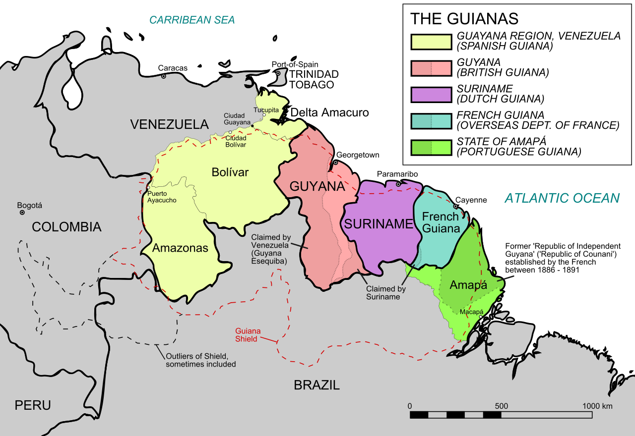
Map of northern South America showing the extent of the Guyanas region

Google Earth

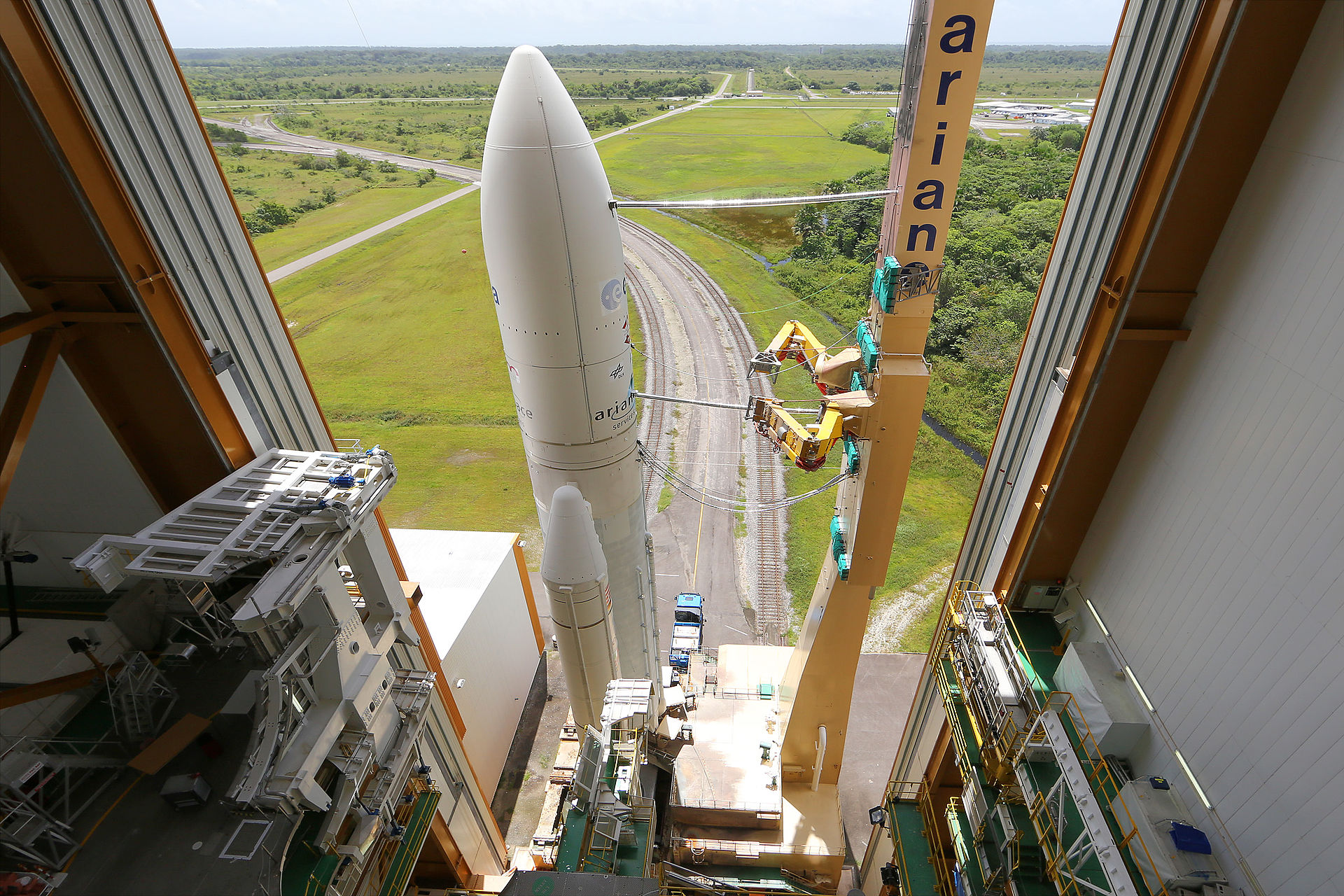
An Ariane 5 rocket being processed at the Guiana Space Centre; the launch site is estimated to account for as much as 16% of French Guiana’s GDP

Photo courtesy of Wikipedia

Last updated on November 22, 2023

Government

According to Britannica, French Guiana is governed by the provisions of the French constitution as a territorial collectivity of France and, as such, forms an integral part of the French Republic. It sends two elected representatives to the National Assembly and two to the Senate. Local government is headed by a prefect and by a 51-member Assembly whose members are elected by universal adult suffrage. There is a local court of appeal. The principal political parties are the Guianese Socialist Party and the Union for a Popular Movement. Other political parties include the Movement for Decolonization and Social Emancipation, the Guiana Democratic Forces, and Walwari, a leftist party whose founder Christiane Taubira served as minister of justice in the administration of French President François Hollande.

Civil / National Aviation Authority (CAA/NAA)

The DGAC, the French Civil Aviation Authority, is responsible for ensuring the safety and the security of French air transport, as well as maintaining a balance between the development of the air transport sector and environmental protection. It is the national regulatory authority, but it also provides safety oversight, air navigation services and training. He is a partner of key players in the aeronautical industry and he is also in charge of financial aid for research in aircraft construction and state industrial policy in this sector.

Airspace

SkyVectorGoogle MapsADS-B Exchange

ICAO countries publish an Aeronautical Information Publication (AIP). This document is divided into three parts: General (GEN), En Route (ENR) and Aerodromes (AD). ENR 1.4 details the types of airspace classes they chose to adopt from classes A through G. French Guiana eAIP

Airspace Classification

Airspace Classification

Drone Regulations

French Drone Laws

European regulations cover the design, maintenance and, to a large extent, the operation of drones, including training requirements and operator obligations. It is common to all EU Member States and is also applied by certain third countries (such as Norway, Iceland, Lichtenstein and Switzerland). It therefore has the advantage of harmonizing the requirements in all EU Member States.
European regulations base their requirements solely on the risk levels of operations:

  • the Open category for low-risk operations,
  • the specific category for moderate-risk operations, and finally
  • the certified category for high-risk operations.

The commercial or professional nature of an operation is not taken into account in the risk assessment.
National regulatory texts remain applicable, in particular to regulate matters falling under national authorities, such as security or the use of French airspace.

These pages provide an overview of the main steps to follow for a drone operator. This content is complemented by guides published by the Direction de la Sécurité de l’Aviation Civile

Guides

Whether you are an operator in an open or specific category, remote pilot or owner of a remotely piloted aircraft, AlphaTango® will allow you to carry out most of the administrative procedures necessary for your activity online.

Model Aircraft Associations

Aeromodelling is a historical activity which was governed by national regulations. European Regulation (EU) 2019/947 has entered into force but allows Member States to define and enforce national rules for model aircraft associations. This is the choice made by France, by defining at national level the safety requirements applicable to model aircraft and their remote pilots when these activities are carried out within a model aircraft association.

All the elements appearing on this page come from the Guide intended for model aircraft associations . Its reading is highly recommended! For any additional information, a Frequently Asked Questions is available below. This FAQ is taken from the now closed Slido Q&A site.

Q&A on European regulatory transition

European regulation 2019/947 concerns the use of unmanned aircraft on board and the requirements applicable to their operators. Although this regulation thoroughly reviews the operating conditions of aircraft without a crew on board, its article 16 allows Member States to define and apply national rules to model aircraft associations. This is the choice made by France, by defining at national level the safety requirements applicable to model aircraft and their remote pilots when these activities are carried out within a model aircraft association: these requirements are the subject of the “aeromodelling associations” decree which comes into force on December 31, 2020. The decree of December 17, 2015 relating to the design of civil aircraft which circulate without anyone on board,

This order applies to the operation within model aircraft associations:

  • of a model aircraft in view of its remote pilot;
  • of a model aircraft with a mass less than or equal to 2 kg, flying out of sight of its remote pilot (case of FPV practice), at a maximum horizontal distance of 200 meters from this remote pilot and at a maximum height of 50 meters, in the presence of a second person in view of this aircraft and responsible for ensuring the safety of the flight by informing the remote pilot of possible dangers;
  • a model aircraft with a mass of less than 1 kilogram which, once launched, evolves within the framework of autonomous operation by following the movements of the atmosphere and whose flight does not last more than 8 minutes (cf. case of aircraft uncontrolled §3.3).

Aeromodelling activities within aeromodelling associations must be the subject of an activity localization.

A model aircraft association can make a request to locate an activity by completing the CERFA 15478*02 form to be sent to the territorially competent DSAC/IR (see DSAC-IR contact details).

The activity location, published in the aeronautical information ( AIP ), includes the practical methods and in particular the maximum flight heights and whether night flying is authorized.

Any operation outside these locations of activity is described in the decree of December 3, 2020 relating to the use of airspace by aircraft without crew on board (article 5). This decree mentions in particular (but not exclusively):

  • the prohibition of flights above public space in built-up areas,
  • the obligation to notify flights in certain portions of airspace for model aircraft weighing more than 900 grams,
  • a maximum flight height of 120 meters.

Registration and registration of aircraft – Aircraft over 800g must be registered by their owner on the AlphaTango website. This portal allows a remote pilot to carry out all their procedures online. For more details, refer to the page dedicated to AlphaTango.

This obligation to register also applies to all aircraft concerned by electronic reporting (see below). Once the aircraft is registered, its owner is required to affix the registration number to the aircraft and must keep with him an extract from the register of remotely piloted aircraft. This extract must be able to be presented to the authorities in the event of an inspection.

Aircraft over 25 kg must be registered and checked in. The applicable procedure is available below:

Electronic and light signaling – This obligation applies to unmanned aircraft with a mass greater than or equal to 800 g.

Model aircraft categories – The regulations distinguish two categories of model aircraft:

Category A: Model aircraft with a mass of less than 25 kg, non-motorized or comprising a single type of propulsion and respecting the following limitations:

  • Thermal engine(s): total displacement ≤ 250 cm3
  • Electric motor(s): total power ≤ 15 kW
  • Turboprop(s): total power ≤ 15 kW
  • Reactor(s): total thrust ≤ 30 daN, with a thrust/weight ratio without fuel ≤ 1.3
  • Hot air: total mass of gas in cylinders on board ≤ 5 kg

Any captive model aircraft with mass ≤ 150 kg

Category B: all model aircraft not respecting the characteristics of category A

Category B model aircraft can only be used after obtaining an authorization issued by the DGAC

General remote pilot requirements – In France, the minimum age to fly a drone over 800g as a remote pilot is 14 years old. The remote pilot must have undergone training and answered an online questionnaire with 100% correct answers (the number of attempts is unlimited).

This training can either be followed on the Open Category Training site or provided by the FFAM or UFOLEP, two federations whose training is recognized by the DGAC.

The certificate obtained is to be kept by the remote pilot who must be able to present it to the authorities in the event of an inspection.

If the remote pilot is not aged 14 or over or does not hold a training certificate, he must fly on a declared site, under the supervision of a person aged 16 or over and holder of the training certificate.

Special provisions are planned for international competitions, allowing foreign remote pilots to pilot in France for a limited period within the framework of these competitions.

For category B aircraft, the remote pilot must have proven his competence during a test flight and be mentioned on the aircraft’s flight authorization.

Training for pilots in model aircraft associations – The training set up by the DGAC, mandatory for aircraft weighing 800g or more, is recommended for everyone: it presents the essential rules and best practices in the form of videos and fun practical exercises. See the Training sheet for pilots in model aircraft associations.

Usage restrictions – Usage restrictions aim to ensure the safety of other airspace users as well as that of property and people on the ground.

Thus, there are restrictions on the places of flight and on the maximum authorized flight heights. These restrictions are published through aeronautical information, which makes it possible to consult permanent (AIP), urgent or temporary (NOTAM and SUP AIP) aeronautical information.

Outside model aircraft sites, the maximum overflight height is 120 m. Restrictions limiting the height to 120 m exist, for example in the vicinity of aerodromes.

The Geoportal map dedicated to restrictions for the flight of recreational drones will allow you to check your flight possibilities.

In general, the following are prohibited in model aircraft:

  • flights in public spaces in built-up areas,
  • night flights,
  • flying over gatherings of people,
  • the dropping of loads off model aircraft sites,
  • flights “out of sight” of the remote pilot, except in cases where the pilot flies “in immersion” with the assistance of an observer.

Since January 2021, the Civil Aviation Service of French Polynesia (SEAC-PF) has posted a map dedicated to restrictions for drone flights on the main islands of the Society archipelago.

Increase in maximum overflight heights outside model aircraft sites. – At places where the maximum permitted flight height is set at 120 m, the aircraft may rise to a maximum height of 150 m, depending on the conditions:

  • The aircraft is equipped with a telemetry system in working order allowing the remote pilot to know its height precisely;
  • The remote pilot is assisted by a visual observer in charge of detecting conflicts with other aircraft in the model aircraft’s range;
  • the remote pilot holds a training certificate issued by an aeromodelling association Law 1901 and registered as a UAS operator on AlphaTango , according to a program relating to the regulations applicable to unmanned aircraft on board used within the framework of aeromodelling associations , on the use of unmanned aircraft on board outside the locations of activity, on the risks associated with the proximity of other airspace users, on the verification and use of aircraft telemetry equipment , on the control of the height of the aircraft and the applicable limits, on the methods of coordination between remote pilot and observer, and on the procedures applicable in the event of detection of another aircraft.

Protection of the privacy of individuals – Individuals’ right to privacy must be respected. The people present must at least be informed if the aircraft is equipped with a camera or any other sensor likely to record data concerning them.

Any dissemination of an image making it possible to recognize or identify people (faces, license plates, etc.) must be authorized by the persons concerned or the owner in the case of a private space (house, garden, etc. ) and this dissemination must respect the rights to the image, privacy and private property of individuals.

Map of restricted areas for the Open category and model aircraft in metropolitan France – The map of restricted areas for the Open category and model aircraft in metropolitan France can be viewed on Geoportail.

The DGAC has developed with the help of the IGN (National Institute for Geographic and Forest Information) an interactive map of restrictions for recreational drones. It represents in a simplified and easily understandable way zones between 0 and 120m, on the whole of the French metropolitan territory, in which the flights of aircraft circulating without people on board are subject to prohibitions or restrictions. This map is based on the decree of December 3, 2020 relating to the use of airspace by aircraft circulating without anyone on board.

In areas where restrictions apply, flights are either totally prohibited or subject to specific authorization by the area manager. Flight in an open category without authorization is therefore not possible. In built-up areas, the flight of drones in the Open category is prohibited in public spaces.

The use of this card must be complementary and not substitute for a good knowledge of the regulations. Consultation of the “Open category” guide is essential.

Card support can be contacted at dgac-carte-drones@aviation-civile.gouv.fr.

While this map allows for an extended visualization of space restrictions, users’ attention is drawn to some current limitations:

  • private heliports are not included in the current version;
  • temporary bans on flying over natural areas during nesting periods are not represented. The existence of these zones is known in the prefecture;
  • In general, for all areas created on a temporary basis, it is advisable to consult the website of the Aeronautical Information Service.

Publication in FRANCE of geographical zones for aircraft without crew on board – Commission Implementing Regulation (EU) 2019/947 of 24 May 2019 concerning the rules and procedures applicable to the operation of unmanned aircraft on board provides in its article 15 that information relating to geographical areas for unmanned aircraft crew on board established for geovigilance purposes are made public by the States in a single and common digital format.

A geographical area is a part of the airspace in which special conditions apply to the operation of UAS for reasons of security, privacy and protection of personal data, safety or environmental.

In France, including in its overseas departments and communities, the special conditions that apply in the geographical areas are established by regulatory texts, including the decree of December 3, 2020 relating to the use of airspace by unmanned aircraft.

Geographical areas can take the form, for example, of controlled airspace, restricted or prohibited areas, hearts of national parks or areas signaling the presence of an establishment bearing a mark prohibiting overflight at low altitude. .

The first catalog of information relating to geographical areas is available in EUROCAE ED-269 format on the SIA website .

The file is accompanied by an explanatory notice which specifies in particular the conditions of use of this information and the procedures for updating it. It is up to the remote pilot to ensure that he complies with the regulations in force, in particular with regard to prohibitions on overflight below a certain height, which apply in national airspace.

Links and Resources – Guides published by the DSAC:

These guides, in the launch version, are continuously updated to incorporate the latest national regulatory references.

In addition, an introductory presentation intended for all categories of operators and manufacturers is also available.

For any additional information and questions, a question/answer site is available to you: we invite you to ask your questions or to vote for the questions asked by the other participants. The DSAC will answer the most frequently asked questions.

European regulations

  • Commission Delegated Regulation (EU) 2019/945 of 12 March 2019 on unmanned aircraft systems and third country operators of unmanned aircraft systems on board
  • Commission Implementing Regulation (EU) 2019/947 of 24 May 2019 concerning the rules and procedures applicable to the operation of unmanned aircraft on board


Punishments

The decree setting the criminal penalties applicable in the event of breaches of the obligations introduced by the law of November 24, 2016 was published on November 28, 2019.

For the use of unmanned aircraft on board with a mass greater than 800 grams, the lack of training of the remote pilot and of registration of the aircraft by its owner are now punishable by a fine.

Shooting

Training for remote pilots in model aircraft associations

Training intended for remote pilots in possession of an aircraft with a mass equal to or greater than 800g.

U-space: digital drone air traffic management

Since 2012 in France and more widely since 2019 in Europe, drone flights have had a regulatory framework aimed at offering the best conditions for the civil operation of these flying machines while preserving safety. These rules for access to airspace are supplemented by a solution common to all European Union countries and called “U-space”. U-space facilitates the use of drones that is safe and protective of the environment and privacy. With entry into force on January 26, 2023, the U-space regulatory framework benefits all operators, service providers, companies, communities and citizens concerned by the use of civilian drones.

U-space refers to air traffic management of unmanned aircraft (UAS), with a high level of automation and digitization, guaranteeing a safe integration of these drones into airspaces from a point of view. view of security and safety, but also respectful of the environment and protection of privacy.

The principle of U-space is the systematic use, in certain airspaces, of a set of digital services provided online to UAS operators or remote pilots. These services are designed for flight safety, including that of manned aviation.

All airspaces with a particular need – safety, security, environment or privacy – related to drones are likely to benefit from a “U-space”. This can concern any type of airspace, whether controlled or not, in urban or rural areas, around aerodromes or even in the airspaces of airports.

The 3 key elements of U-space

The U-space is based on 3 main elements:

  • Airspaces designated U-space by the State and in which the vast majority of aircraft flying there are drones. These spaces can be penetrated by manned aircraft under certain conditions:
  • Standardized digital services called “ U-space services ”. Four of these services are compulsorily provided to UAS operators inside U-space spaces. The providers of these services are called “U-space service providers” (USSP or U-space service provider). They must have a European certificate issued by the national authority of a European State or by the European Union Agency for Aviation Safety (EASA);
  • Common information services ( CIS or common information service), forming a basic digital infrastructure for each U-space. They consist of the provision of data allowing the use of U-space services and therefore circulation in U-space (e.g. information on airspace and traffic) for the needs of USSPs but also air navigation service providers, drone operators and all other stakeholders (eg Air Force).
    A single service provider in a U-space area may be designated by the State to provide these CIS services. This type of service provider is called a single CISP (common information service provider). He must also have a European certificate.

The U-space regulatory framework is based on three European Union regulations and a set of Acceptable Means of Compliance and EASA Guides:

Inside U-space, the following four services must be provided by USSPs to UAS operators:

  • Network ID service that enables continuous processing of UAS remote identification, operator registration, and dissemination of information about their operations, including drone and remote pilot positions
  • Geovigilance service , which informs UAS operators of applicable operating conditions in U-space and airspace constraints, including possible changes to the configuration of the space in which it is cleared to fly ( dynamic airspace reconfiguration )
  • UAS Flight Authorization Service , which grants UAS operators flight authorizations based on operating area interference with U-space constraints and other flight activities; the flight authorization service also provides for the review, or even the suspension, of each authorization according to changes in the conditions of evolution inside a U-space
  • Traffic Information Service , which aims to provide the UAS operator with information about any other discernible air traffic, including manned, that may be occurring near the UAS flight’s intended position or route and to allow him to take the necessary measures to avoid any risk of collision

The use of weather information service or compliance monitoring service may also be required by regulation, based on the airspace risk assessment . These optional services can also be offered at the initiative of the USSPs.

The performance of services provided by USSPs are specified based on an airspace risk assessment performed as part of the designation of each U-space.

Single USSPs and CISPs must have a certificate issued by the territorially competent national authority. It is the Civil Aviation Safety Department (DSAC) of the DGAC which is competent for the certification of these service providers whose main establishment is located in France. EASA is responsible for service providers who have their main establishment, are established or reside in a country outside the agency.

Certification is issued after instruction to service providers who can demonstrate their compliance with the applicable requirements of Commission Implementing Regulation (EU) 2021/664 of 22 April 2021 on a regulatory framework for U-space and its AMCs.

Certification by the DSAC takes place in 7 stages:

  1. Declaration of candidacy by the candidate service provider
  2. Appointment by the DSAC of an agent within it responsible for certification and implementation of a certification plan in coordination with the candidate service provider
  3. Production of a certification file by the candidate service provider
  4. Study of the certification file by the DSAC
  5. Certification audit by the DSAC of the candidate service provider, if applicable
  6. Treatment of any non-conformities
  7. Issuance of the certificate, if applicable

After certification, the service provider enters the continuous monitoring phase by the DSAC.

Exchanges between service providers and the DSAC, which are related to their certification or continuous monitoring, are carried out with the METEOR application

For any questions relating to the certification and monitoring of USSP and CISP service providers, contact: dsac-u-space-certification-ld@aviation-civile.gouv.fr

A file allowing candidates to apply for the issue of the European certificate of U-space service provider or single provider of common information services will soon be made available.

CISP (Common Information Service Provider): Common information service provider. They are said to be “single common information service provider” (single CISP) when they are designated by a State to provide the common information services on an exclusive basis in all or part of a U-space airspace

U-space airspace: a UAS geographical area designated by Member States, in which UAS operations are only permitted with the support of U-space services

Airspace risk assessment: an assessment of operational risks and safety and security risks, taking into account the required levels of safety performance defined in the European plan for aviation safety and the national program safety measures referred to, respectively, in Articles 6 and 7 of Regulation (EU) 2018/1139, the type, complexity and density of traffic, location, altitudes or heights and classification of the airspace

Electronic Perceivability: Ability to make itself permanently electronically perceivable to U-space service providers by one of the acceptable means of compliance with Regulation 2021/666 (e.g. ADS-B “Out” 1090 MHz)

Main establishment: the central administration or registered office of a U-space service provider or a common information service provider in the Member State in which the main financial functions and operational control of the provider are carried out Services

Dynamic Airspace Reconfiguration: the temporary modification of U-space airspace to accommodate short-term changes in manned aircraft traffic demand, by adjusting the geographical boundaries of that U-space airspace -space.

Common Information Service: a service disseminating static and dynamic data to enable the provision of U-space services for the purpose of traffic management of unmanned aircraft on board

U-space service: a service based on digital services and automation of functions, designed to ensure that a large number of UAS have secure, safe and efficient access to U-space airspace

UAS (Unmanned Aircraft System) or “aircraft system without a crew on board”: any aircraft without a crew on board and the equipment used to control it remotely


Advanced Air Mobility (AAM)


Short Essay Questions

Question 1

You have been hired by a Drone Startup Company. Your boss has immediately assigned this job to you.

They need you to prepare a one-page memo detailing the legalities of using a drone to film in French Guiana, pictured above.

They need you to mention any national laws and local ordinances.

They specifically want to know what airspace you will be operating in and whether or not you need an airspace authorization.

Does it matter whether or not you are a citizen of the country?

Lastly, there is a bonus for you if, as you scroll through this chapter, you find any typos or broken links!

Question 2

Do you need a certificate to fly UAS?

If so, how do you obtain one?

Are there fees associated with this?

If so, how much?

Question 3

May you operate beyond visual line of sight?

If so, what procedures must you follow?

Question 4

Does the country have UAM/AAM laws? If so, describe, citing the exact law.

Question 5

Are you aware of any new laws or policies not mentioned above? If so, describe, citing the exact law or policy.


License

Icon for the Creative Commons Attribution-NonCommercial-NoDerivatives 4.0 International License

Drones Across the World Copyright © 2023 by Sarah Nilsson is licensed under a Creative Commons Attribution-NonCommercial-NoDerivatives 4.0 International License, except where otherwise noted.

Share This Book