20 Guatemala
Three equal vertical bands of light blue (hoist side), white, and light blue, with the coat of arms centered in the white band. The coat of arms includes a green and red quetzal (the national bird) representing liberty and a scroll bearing the inscription LIBERTAD 15 DE SEPTIEMBRE DE 1821 (the original date of independence from Spain) all superimposed on a pair of crossed rifles signifying Guatemala’s willingness to defend itself and a pair of crossed swords representing honor and framed by a laurel wreath symbolizing victory. The blue bands represent the Pacific Ocean and Caribbean Sea; the white band denotes peace and purity.
Flag courtesy of the CIA World Factbook
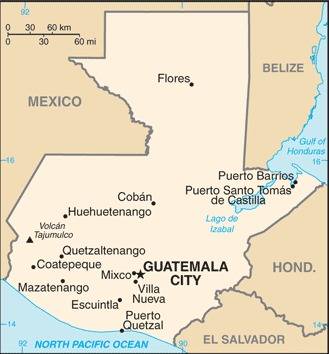
Map courtesy of CIA World Factbook

Indian masks at an open-air market.
Photo courtesy of the CIA World Factbook
Government
According to Britannica, the constitution adopted in 1986 defines the country as a sovereign democratic republic and divides power among three governmental branches: legislative, executive, and judicial. Legislative power is delegated to a unicameral Congress, whose members are elected to five-year terms through direct, popular suffrage. Executive power is vested in the president, who is both the head of government and the head of state, and the vice president, both of whom are also elected to five-year terms by popular vote.
Guatemala is divided into departamentos (departments), each headed by a governor appointed by the president. The departments in turn are divided into municipios (municipalities), which are governed by councils presided over by mayors, elected directly by popular ballot.
The Supreme Court, with at least nine justices, has jurisdiction over all the tribunals of the country. The justices are elected by Congress for terms of four years.
Civil / National Aviation Authority (CAA/NAA)
The General Directorate of Civil Aeronautics is the institution responsible for regulating, managing, strengthening, facilitating, and monitoring the provision of airport, navigation, and air transport services, in accordance with current legislation and international agreements ratified by the state of Guatemala.
Airspace
SkyVector – Google Maps – ADS-B Exchange
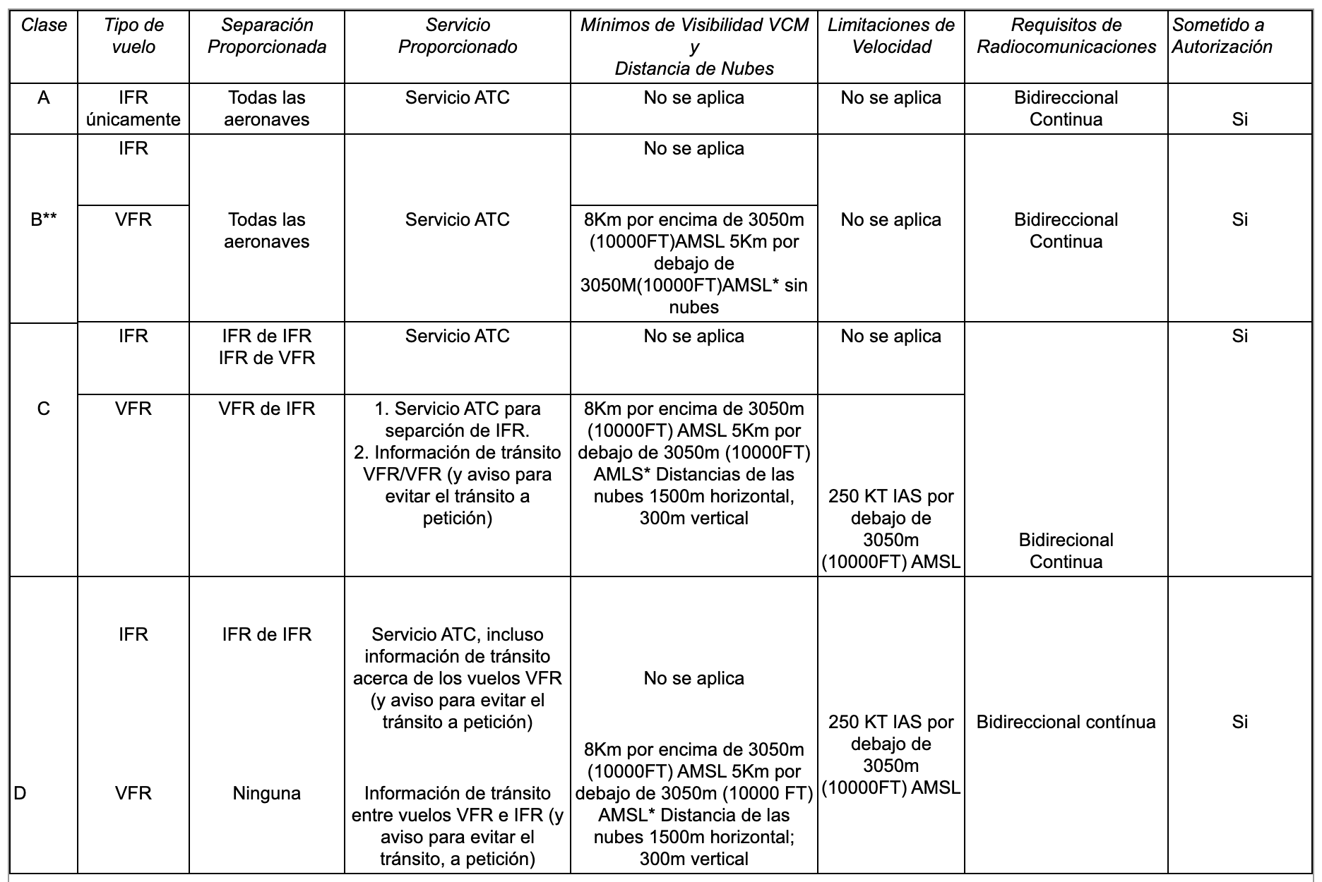
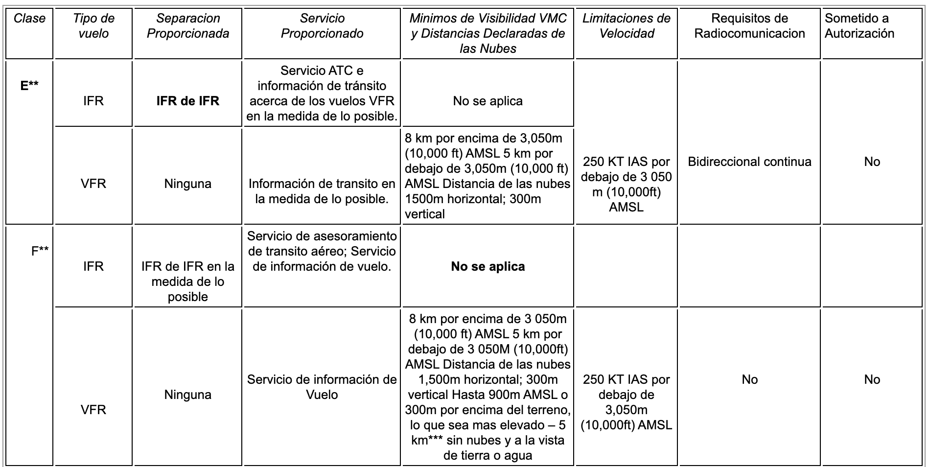
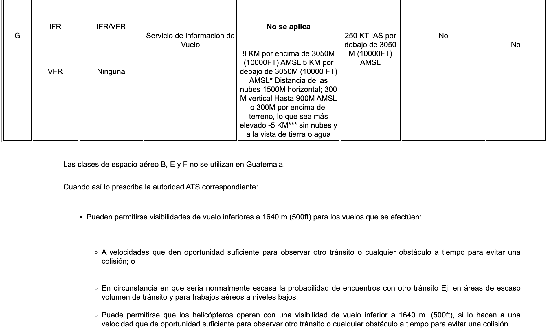
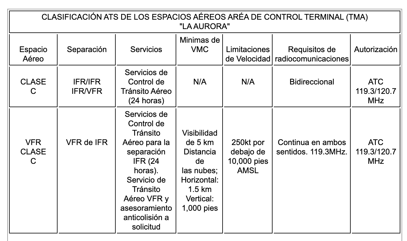
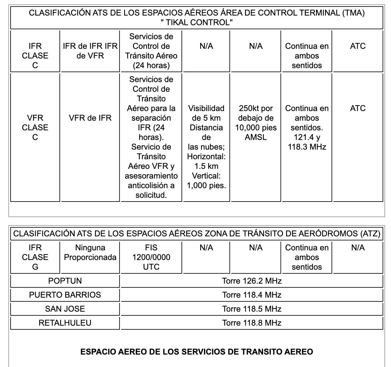
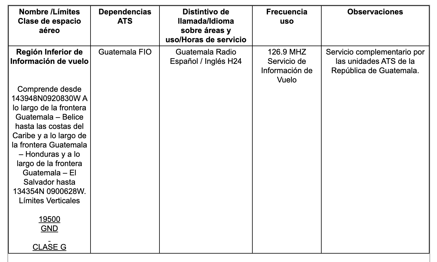
ICAO countries publish an Aeronautical Information Publication (AIP). This document is divided into three parts: General (GEN), En Route (ENR) and Aerodromes (AD). ENR 1.4 details the types of airspace classes they chose to adopt from classes A through G. Guatemala eAIP
The Central American Corporation for Air Navigation Services (COCESNA) is an International Organization for Central American Integration, non-profit and public service, with legal status and financial autonomy, created on February 26, 1960 and governed by a Board of Directors, which it is constituted in its highest collegiate body, which is made up of the representatives of the signatory States of its Constitutive Agreement; established with well-defined objectives and purposes to respond and jointly comply with civil aviation international commitments contracted as signatory countries of the Convention on International Civil Aviation of 1944, known as the Chicago Convention. In that order, COCESNA enjoys the exclusive rights to provide Air Traffic, Aeronautical Telecommunications and Radio Assistance services in the territories of the Member States and other services established in the regional plans that have been entrusted to it by the Contracting Parties. under an international agreement. Its operations are fundamentally based on the Standards and Methods recommended by the ICAO. The adherence to the established norms and the search for excellence constitute COCESNA’s fundamental objectives.
As a result of the notable progress in aviation at the end of the 1950s, especially with the entry into service of jet aircraft, the need to modernize and strengthen the region’s air navigation services was valued, for which, in the month November 1959, a meeting with the Directors was held in Guatemala. Generals of Civil Aeronautics of Central America at that time, within which it was agreed to convene a Diplomatic Conference aimed at establishing a specialized regional organization, with the necessary human and financial resources to meet these modern requirements, as well as to unify and coordinate regional intergovernmental efforts and actions that would benefit the users of these services. Therefore, from February 22 to 26, 1960, the V Conference of Directors of Civil Aeronautics was held in Tegucigalpa, Honduras, signing the guidelines of the Central American Corporation of Air Navigation Services -COCESNA, thus marking the beginning of its existence and operation. Consequently and by virtue of its nature, on February 1, 1961, its Constitutive Agreement was registered with the International Civil Aviation Organization – ICAO and on January 2, 1962 with the United Nations (UN). During the year 1963, COCESNA acquires the official recognition of the States of the Central American isthmus, through decrees and laws that ratified its Constitutive Agreement issued by the Legislative Assemblies of each Member State. Guatemala is a member state of COCESNA.
Drone Regulations
Drone Laws include Circulars, Unmanned Aircraft Registration Form, Equipment Evaluation Form, Special Permission Form, Individual Registration, etc.
AIC A 10-20 21 FEB Translated into English by Google
Translations
Translations of any materials into English are intended solely as a convenience to the public and are not legally binding. The author has merely attempted to provide a Google translation of the original material to English for convenience. Due to the nuances in translating to a foreign language, several differences may exist so before using for any work or pleasure please have the document translated by a professional service!
AIC A 10-20 21 FEB
It is necessary to remind all operators of unmanned aircraft to respect the limits of altitude for its operations established in the Civil Aviation Regulation (RAC) 101.23, which establishes 400 feet AGL, likewise any operation that is carried out on terraces of houses, buildings or their constructions are failing to comply with the provisions of numeral previous.
The general public is requested to become aware of operational safety and report their unmanned aircraft in the DGAC, to comply with the provisions of the Regulation of Civil Aviation (RAC) 101 and request the corresponding permits to carry out their operations.
The State of Guatemala through the DGAC, for purposes of maintaining Security Civil Aviation Operations, requests the collaboration of Security and Justice institutions to help prevent the misuse of these aircraft and implement the necessary measures to ensure operational safety.
For more information, you can consult our website: www.dgac.gob.gt or you can contact the Operational Safety Surveillance Management for the necessary consultations, in the second level of the building of this Directorate.
This AIC cancels AIC C 03-18, AIC A 25-19, A 29-19, A 30-19.
AIC A 43-18 06 MAR
Forbidden overflight of DRONES,
Forbidden overflight of DRONES,
unmanned aircraft in the DGAC, to comply with the provisions of the Regulation of Civil Aviation (RAC) 101 and request the corresponding permits to carry out their operations.
The State of Guatemala through the DGAC, for purposes of maintaining Operational Security of Civil Aviation, requests the collaboration of Security and Justice institutions to help prevent the misuse of these aircraft and apply the necessary measures to guarantee safety operational.
For more information, you can consult our website: www.dgac.gob.gt or you can contact the Operational Safety Surveillance Management for the necessary consultations, in the second level of the building of this Directorate.
Advanced Air Mobility (AAM)
Short Essay Questions
Question 1
You have been hired by a Drone Startup Company. Your boss has immediately assigned this job to you.
They need you to prepare a one-page memo detailing the legalities of using a drone at an open-air market in Guatemala City, pictured above.
They need you to mention any national laws and local ordinances.
They specifically want to know what airspace you will be operating in and whether or not you need an airspace authorization.
Does it matter whether or not you are a citizen of the country?
Lastly, there is a bonus for you if, as you scroll through this chapter, you find any typos or broken links!
Question 2
Do you need a certificate to fly UAS?
If so, how do you obtain one?
Are there fees associated with this?
If so, how much?
Question 3
May you operate beyond visual line of sight?
If so, what procedures must you follow?
Question 4
Does the country have UAM/AAM laws? If so, describe, citing the exact law.
Question 5
Are you aware of any new laws or policies not mentioned above? If so, describe, citing the exact law or policy.
