AZ – Arizona


Bell Rock is a butte south of Sedona, Arizona composed of horizontal beds of late Permian (approx. 285 million year old) sedimentary rock.
Photo courtesy of the CIA World Factbook

Last updated on October 18, 2025
Airspace
In addition to checking the FAA UAS Facility Map or SkyVector or Google Maps one should consider also FAA JO 7400.10G – Special Use Airspace which is an order, published yearly, providing a listing of all regulatory and non-regulatory special use airspace areas, as well as issued but not yet implemented amendments to those areas established by the FAA.
Special Use Airspace consists of airspace of defined dimensions identified by an area on the surface of the earth wherein activities must be confined because of their nature, or wherein limitations are imposed upon aircraft operations that are not a part of those activities, or both. The vertical limits of special use airspace are measured by designated altitude floors and ceilings expressed as flight levels or as feet above MSL. Unless otherwise specified, the word “to” (an altitude or flight level) means “to and including” (that altitude or flight level). The horizontal limits of special use airspace are measured by boundaries described by geographic coordinates or other appropriate references that clearly define their perimeter. The period of time during which a designation of special use airspace is in effect is stated in the designation. All bearings and radials in this part are true from point of origin. Unless otherwise specified, all mileages in this part are stated as statute miles.
Restricted Areas: No person may operate an aircraft within a restricted area between the designated altitudes and during the time of designation, unless they have the advance permission of:
(a) The using agency described in § 73.15; or
(b) The controlling agency described in § 73.17.
These using agencies may be the agency, organization, or military command whose activity within a restricted area necessitated the area being so designated. Upon the request of the FAA, the using agency shall execute a letter establishing procedures for joint use of a restricted area by the using agency and the controlling agency, under which the using agency would notify the controlling agency whenever the controlling agency may grant permission for transit through the restricted area in accordance with the terms of the letter. The using agency shall:
(1) Schedule activities within the restricted area;
(2) Authorize transit through, or flight within, the restricted area as feasible; and
(3) Contain within the restricted area all activities conducted therein in accordance with the purpose for which it was designated.
For the purposes of this part, the controlling agency is the FAA facility that may authorize transit through or flight within a restricted area in accordance with a joint-use letter issued under § 73.15.
Prohibited Areas: No person may operate an aircraft within a prohibited area unless authorization has been granted by the using agency. For the purpose of this subpart, the using agency is the agency, organization or military command that established the requirements for the prohibited area.
Military Operations Areas: A Military Operations Area (MOA) is airspace established outside of Class A airspace to separate/segregate certain nonhazardous military activities from IFR traffic and to identify for VFR traffic where these activities are conducted. Activities. MOA’s are established to contain certain military activities such as air combat maneuvers, air intercepts, acrobatics, etc.
Alert Areas: Airspace which may contain a high volume of pilot training activities or an unusual type of aerial activity, neither of which is hazardous to aircraft.
Warning Areas: A non regulatory warning area is airspace of defined dimensions designated over international waters that contains activity which may be hazardous to nonparticipating aircraft. The purpose of such warning areas is to warn nonparticipating pilots of the potential danger. Activities may be hazardous.
National Security Areas: A national security area (NSA) consists of airspace of defined vertical and lateral dimensions established at locations where there is a requirement for increased security of ground facilities. The purpose of such national security areas is to request pilot cooperation by voluntarily avoiding flight through the NSA. When circumstances dictate a need for a greater level of security, flight in an NSA may be temporarily prohibited by regulation under the provisions of 14 CFR Section 99.7, Special Security Instructions. Such prohibitions will be issued by FAA Headquarters and disseminated via the US NOTAM System.
Video courtesy of James and Angel (former ERAU students of mine)
Crewed Aircraft in your Airspace
CREWED AIRCRAFT
AZDOT
Arizona State Drone Statutes
Arizona government website just for reference.
Arizona Legislature in case more laws were written since this book was last updated.
Arizona Department of Agriculture for Part 137 operators.
State Preemption Law
28-8277. Low altitude flying prohibited
28-8279. Trick or acrobatic flying; low level flying; dropping objects; classification
28-8280. Careless or reckless aircraft operation; violation; classification; definitions
28-8282. Prohibited operation; under the influence; incapacitation
Local Ordinances and Policies
This list may not be complete. Always check for any local ordinances that may have been published in search engines such as American Legal Publishing and Municode Library since this book was last updated.
Apache Junction
§ 15-1-3 PROHIBITED ACTIVITIES.
§ 15-1-4 ENFORCEMENT AND PENALTY.
Arizona Game and Fish Department
Arizona Game and Fish Department Hunting Regulations
Arizona State Parks and Trails
FREQUENTLY ASKED QUESTIONS (FAQ) ABOUT ARIZONA STATE PARKS & TRAILS
Casa Grande
13.04.420 Unauthorized flying of unmanned aircraft systems prohibited.
Coronado National Forest
Coronado National Forest Drone Rules
Marana
15-2-18 Unmanned aircraft systems (UAS)
15-2-19 Model airplanes, model helicopters, kites, and fireworks
Maricopa County Parks and Recreation
R-116 AIRCRAFT AND ENGINE POWERED MODELS
Mesa Parks
Paradise Valley Ordinance
ARTICLE 10-12 RESTRICTIONS AND EXCEPTIONS TO UNMANNED AERIAL VEHICLE OPERATIONS
Payson
Peoria
Sec. 7-62. Parks and recreation areas; regulated activities; violations.
Phoenix
Scottsdale Parks
Scottsdale Parks Flying Drones Safely
Sierra Vista
Snow Bowl Ski Resort
Tempe Parks
Tempe Parks and Recreations Rules
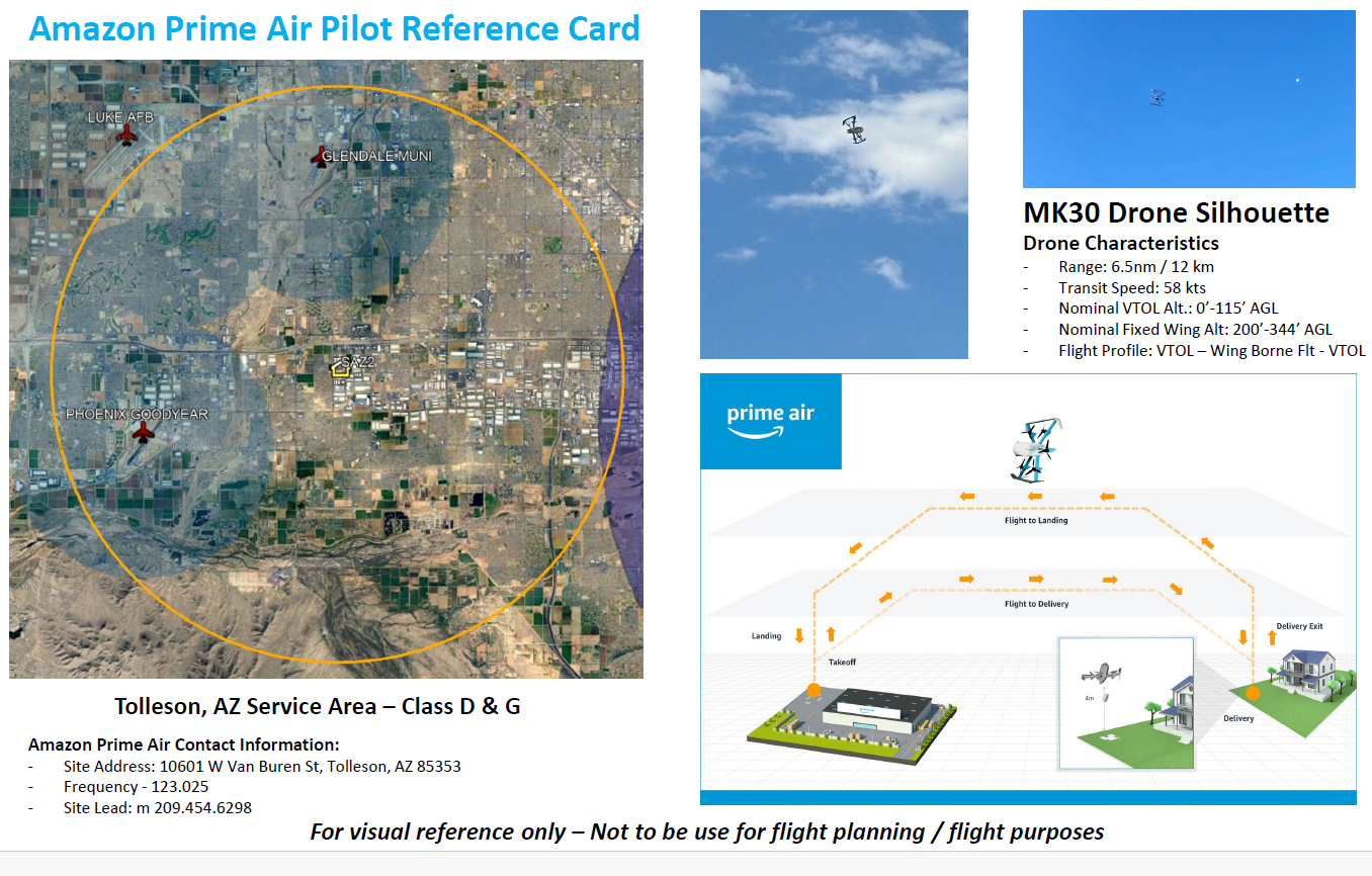
Tolleson Amazon Prime Air
2024 – Amazon has launched our most advanced delivery drone yet—here’s everything you need to know
Tombstone
CHAPTER 8 – UNMANNED AIRCRAFT SYSTEMS (“DRONES”)
Other Laws That May Apply
Additional laws that could be used in Arizona …. besides the UAS specific ones!
Title 28 of the A.R.S. Chapter 25 deals with Aviation
“Aircraft” includes a balloon, airplane, amphibian and craft used for navigation through the air.
13-1424 Voyeurism (mentions a device but does not define it so UAS could be a device)
13-1502 Criminal Trespass in the third degree (“Entry” means the intrusion of any part of any instrument or any part of a person’s body inside the external boundaries of a structure or unit of real property. – see definitions as a UAS could be an instrument)
13-1503 Criminal Trespass in the second degree
13-1504 Criminal Trespass in the first degree
University Drone Policies
Arizona Christian University (page 53-54)
Embry-Riddle Aeronautical University – Prescott Campus Policy
Note: This list is just a sample… many more could be added.
Advanced Air Mobility (AAM) Regulations & Policies
ARS 28-8602. Vertiport and electric aviation planning
A. Beginning September 1, 2026, the department shall:
1. Through consultation with political subdivisions of this state that own or control a public airport, commercial air carriers, the federal aviation administration and any other relevant stakeholders, develop a statewide plan or update the statewide aviation plan to include public vertiports and electric aircraft charging stations and the infrastructure needs of advanced air mobility.
2. Designate a person who has expertise in advanced air mobility within the department as a resource for local and regional jurisdictions that are developing or implementing advanced air mobility, including an electric powered lift aircraft and electric aircraft. The person shall establish working relationships with political subdivisions of this state that own or control a public airport, commercial air carriers, the federal aviation administration, the United States department of transportation and any other relevant stakeholders.
B. A political subdivision of this state, in compliance with applicable federal laws, including those laws that apply to the federal aviation administration’s and the United States department of transportation’s safety standards, may establish the location of public and private vertiports, electric aircraft charging stations and the infrastructure needs of advanced air mobility.
ARS 28-8601. Definitions
In this article, unless the context otherwise requires:
1. “Advanced air mobility” means an air transportation system that primarily uses an electric aircraft, including eCTOL, eVTOL and powered lift aircraft, to carry passengers or cargo in an urban or a regional area.
2. “eCTOL” means an electric conventional takeoff and landing aircraft.
3. “eVTOL” means an electric vertical takeoff and landing aircraft.
4. “Powered lift aircraft” means a heavier-than-air aircraft that is capable of vertical takeoff, vertical landing and low-speed flight and that primarily uses engine-driven lift devices or engine thrust for lifting the aircraft during a takeoff and at least one nonrotating airfoil for lifting the aircraft during horizontal flight.
5. “Vertiport” means an area of land or water or a structure that is primarily used for the takeoff or landing of a powered lift aircraft, including associated buildings or facilities.
2025 – ADOT – Links and Resources – Airport Development
2022 – Urban Air Mobility Study Committee
2021 – State of Arizona, in the House of Representatives, in the 55th Legislature, First Regular Session, 2021
Chapter 197 was enacted from House Bill 2485.
AN ACT ESTABLISHING THE URBAN AIR MOBILITY STUDY COMMITTEE.
Advanced Air Mobility (AAM) News
2025 – Arizona city seeks to become advanced air mobility innovator
2024 – Arizona updates advanced air mobility objectives, focuses on AI
2023 – Lawmakers explore development of flying drone taxis
2020 – Honeywell Aerospace, located in Phoenix, which has long been a supplier of avionics, propulsion, and other technology for jetliners and military aircraft, since 2020 is home to an AAM lab
Short Essay Questions
Question 1
You have been hired by a Drone Startup Company. Your boss has immediately assigned this job to you.
They need you to prepare a one-page memo detailing the legalities of filming Bell Rock, a butte south of Sedona, Arizona, pictured above.
They need you to mention any state laws and local ordinances.
They specifically want to know what airspace (insert pictures) you will be operating in, and whether or not you need an airspace authorization, with or without LAANC capability.
Lastly, there is a bonus for you if, as you scroll through this chapter, you find any typos or broken links!
Question 2
Do the state drone laws implicate the First Amendment? If so, describe, citing the exact law.
Question 3
Do the state drone laws implicate the Fourth Amendment? Or involve law enforcement officers obtaining warrants? If so, describe, citing the exact law.
Question 4
Do the state drone laws contain a preemption clause? If so, describe, citing the exact law.
Question 5
Does the state have UAM/AAM laws? If so, describe, citing the exact law.
Question 6
Are you aware of any new laws or policies not mentioned above? If so, describe, citing the exact law or policy.
